
LETTER TO THE EDITOR
- Magnetic Community News
- Mar 25
- 5 min read
NELLY BAY HARBOUR DREDGING
The federal Environment Minister, Tanya Plibersek
The federal Member for Herbert, Phillip Thompson
The state Member for Townsville, Adam Baillie
The (Acting) Mayor of Townsville, Ann-Maree Greaney
Townsville Bulletin’s Nikita McGuire
Magnetic Community News’ Debbie Dennison
TO WHOM IT MAY CONCERN
Townsville City Council proposes to dredge some components of the Nelly Bay harbour to “maintain reasonable navigable depths” in line with Council’s maintenance responsibilities. It is further proposed to stockpile dredge spoil on Council land in Nelly Bay where it can be treated for any contamination and remediated for later re-use. Several issues have arisen. The purpose of this letter is to air some of those issues.

I have taken a snapshot from P.12 of the Dredge Management plan in TCC’s OPW23/0028 report by consultants SMEC. I have magnified a small section of the Pre-Dredging Hydrographic Survey (below) so we can actually read the numbers and see the underlying detail. Peculiarly, there is no intelligible key on the diagram to explain what the colour code is. I interpret it thus:
The pink area lower right is deep water at apparently OK navigable depth for the barge and ferry swing basin (and a little bit off the end of the reclaimed subdivision called The Cove).
The blue area is apparently OK navigable depth in the ‘keyhole’ marina, in the approach to the Gustav Creek section of canal estate and in the general harbour approaches to the boat ramp.
The brown area is some level of sedimentation, maybe not yet requiring actual action. The sedimentation is from flood inflows from Gustav Creek (top left), from a small unnamed creek flowing into the marina basin at top right, and from historic (ie. since 2003) sand migrating along Nelly Bay beach into the harbour under the Kelly Street bridge, bottom left, particularly before a sandbag groyne was a constructed a few years ago.
The red area, which is pretty much continuous around the entire inner margin of the harbour, is the target of at least part of the TCC dredging program though maybe not all at once, all this year, or all the way around the inside of the breakwater. No one seems to want to explain the precise detail. Much of the sedimentation along the ‘beach’ on the inside of the breakwater is the result of waves overtopping the breakwater in various cyclones, severely eroding the original dredge spoil which constitutes the breakwater island and washing this material into the excavated harbour basin.
Each of the four target areas has an amount proposed to be removed (marked on the diagram):
“Marina” 1,942m3
“Creek” 2,908m3
“Bridge” 1,866m3
“Extra Bridge” 881m3
Total: 7,597m3
None of this tally appears to apply to the harbour proper where significant ‘red areas’ are marked.
It is not exactly clear whether this is the total extent of the TCC dredging program because some of the red (and brown) area near the ‘beach’, near the boat ramp and at the corner of the boat ramp carpark is clearly not part of TCC’s canal estate. In other words, these areas are in the harbour proper, a state-controlled area (Transport and Main Roads?). This may be the reason why GBRMPA has issued a separate permit to TCC for dredging work to be carried out in what they (GBRMPA) describe as "HABITAT PROTECTION ZONE – Magnetic Island Reef east (19-5161) waters within the Nelly Bay Harbour Approved Dredge Area”. In other words, this part of the harbour is within the Great Barrier Reef Marine Park whereas the adjacent TCC canal estate and keyhole marina are not. The GBRMPA Permit is for 4,700m3 to be taken from an unspecified area within the harbour. I cannot get a clear answer from TCC or GBRMPA, let alone the Queensland government, whether this 4,700m3 is part of the “7,000m3” said to be the extent of the dredging program for 2025, or whether it is in addition to this. In other words, the entire program may be 7,000 + 4,700 = 11,700m3. The TCC spokesman at the recent Horseshoe Bay information session has said that some of the quantity estimates are now a bit dated (2021) and recent heavy rain since Christmas 2024 will have brought even more sediment down, especially from the Gustav Creek catchment. So all the numbers could be conservative if not large underestimates.
So, if either 40% (of 11,700m3) or 67% (of 7,000m3) of the proposed dredging is to be carried out to rectify sedimentation problems in the Queensland government-controlled harbour proper, why are Townsville ratepayers alone paying the full price for all these works? And why should they be providing rare and valuable community facility land, possibly in perpetuity, for this industrial process to take place from time to time? In addition, TCC has proposed that once the thousands of tonnes of spoil are treated and stabilised it will be offered free to anyone who wants to use it for whatever purpose. It could even be used to ‘replenish’ the Nelly Bay beach apparently. Given that the Council has admitted it will not know what the makeup (in terms of sand, silt and clay fractions) or qualities (organic matter, contaminants, trash) of the remediated spoil will be, nor any of the likely locations it could be dispersed to, there is potential for the material to be misused or be placed in entirely unacceptable locations where it could cause contamination or downstream sedimentation of local watercourses draining back into the surrounding Marine Park. This vagueness, if not actual ignorance or dismissal of consequences perhaps explains GBRMPA’s, TMR’s and TCC’s outright refusal to refer the project to the federal environment minister for assessment under the EPBC Act. What is the problem? Could it be that the proponents know that Magnetic Island’s World Heritage values, already acknowledged in Commonwealth documentation, could be placed at risk?
Which begs the question why, given that maintenance dredging will be a permanent and ongoing issue in the harbour, is community property at Nelly Bay being proposed as a spoil dump and industrial remediation site in the first place? The Queensland and Australian governments have recently jointly funded a dredge spoil reclamation area at Townsville for the Port Expansion Project, recently completed. This extensive reclamation area next to the port, just a few kilometres away, could take untreated spoil from Nelly Bay ‘as is’. Why won’t the state government take responsibility for its Nelly Bay dredge spoil? Why are state and federal members of parliament demanding answers from the local council when their governments made the foundation decisions, are now calling the shots and of course are holding the purse strings?

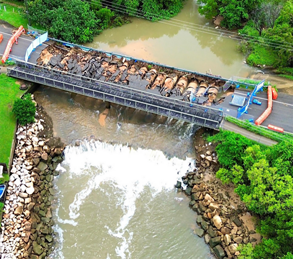
The build up of sediments, from various sources, in critical areas of the Nelly Bay harbour, is a result of flaws in the original design. The so-called ‘sediment trap’ just upstream of the Sooning Street bridge, currently obliterated by recent flooding, is totally inadequate and urgently needs re-design. The small unnamed creek entering the marina is completely unregulated. Sand movement along the Nelly Bay beach is, at least temporarily, somewhat impeded by a sandbag groyne although this is incomplete and requiring further development.
Sooning Street bridge/causeway and the mangrove-lined upstream ’sediment trap’, March 2025.
The main island breakwater, already cyclone damaged, already raised and re-armoured twice since construction, cannot prevent even medium waves overtopping, damaging installed infrastructure and eroding the fragile, mobile dredge spoil the inner beach was built from. It is unacceptable that Townsville City Council ratepayers are being held responsible for all the shortcomings of the Nelly Bay harbour which was built by the state and approved by the federal government.
It is about time state and federal governments took responsibility for their share of this decision making failure.
Yours faithfully,
H.O. (Charlie) McColl
Nelly Bay
Comments